Only five-hours away from France by airplane, we are going to have the fascinating experience of discovering Gran Canaria Island, where few places offer so many possibilities for adventure, passion and contact with nature. Located 50 miles (96 km) from the African coast, opposite Morocco, the island is a climatic miracle, thanks partly to the damp trade winds and ocean currents. The combination of these two factors with the elevation differences that delimit and define well-differentiated zones, produce scenery contrasts that give the island the nickname “miniature continent”. From the hot environment of the coast, where most tourists stay, to the high mountain summits, passing through subtropical valleys and woods, visiting Gran Canaria is like crossing several countries in a few miles, always with the gentle, spring-like temperatures that occur year-round. It is a change from our hexagon’s atrocious springtime. The island is an enormous mountain in the conical shape of a pyramid, which volcanoes raised from the ocean millions of years ago. Its maximum height is reached at Pico de las Nieves (Snow Peak, alt. 1949 m/6394 ft) located in the geographic center. Our itinerary consists of 10 stages for a daily average of 50 km (31 miles), nothing to make a fuss about, but the elevation changes are important. It is interspersed with three rest days for Barbara, and supplemented along the way by a few passes, 40 in all.
Saturday, April 28: The trip: Paris - Las Palmas
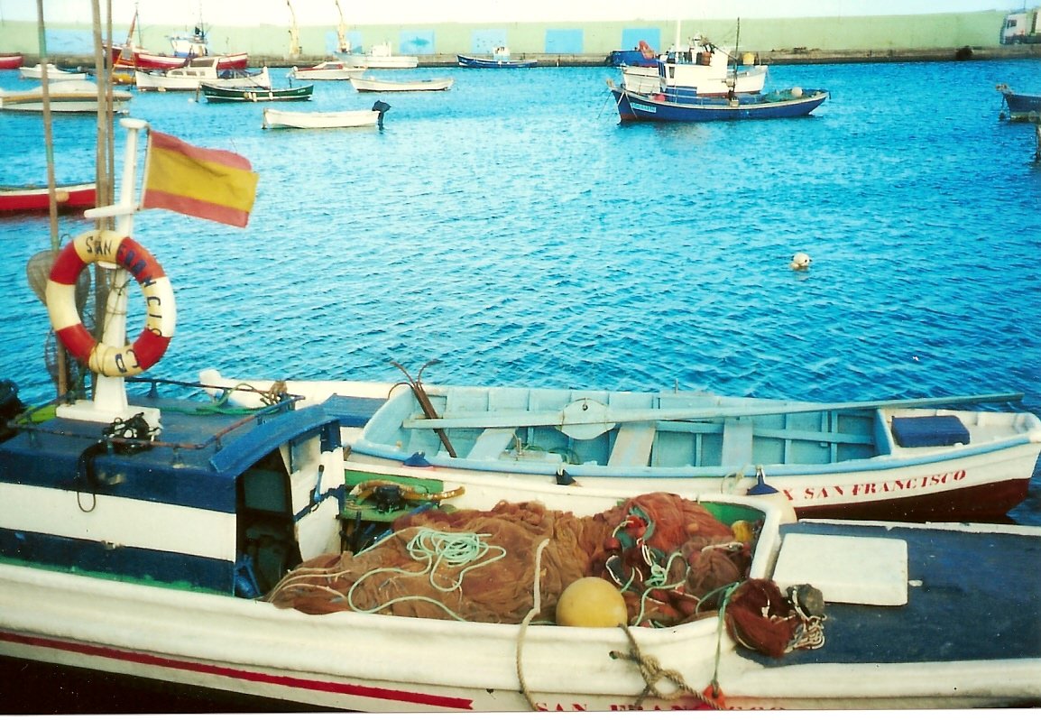
These are not major manoeuvres, but almost like one. I have set the departure meeting with Barbara at 5:10 a.m.! on bicycles. This is practical and economical at the same time. We go to Invalides to get onto the Air France bus for Orly Airport. The Iberia flight will take all morning with a stop in Barcelona. We land under a radiant sun, in summer temperatures. Without further waiting, we put on our cycling clothes, since the airport is 10 miles from our vacation place at Playa de Mélénara, with, at the end, the climb of Cuatro Puertas (alt: 250 m/820 ft), to get into the heart of the matter. Rather short, 4 km (2˝ miles), but the gusts of wind require Barbara to hold her handlebars tightly. Pension Oliva welcomes us warmly, next to the small beach with grey sand, where the tourist season hasn’t yet started. The hotel is ideally located. Its feet are in the water, and on the balcony, we have the impression of being on the bridge of a ship. The only disadvantage, at night, the noise of the waves.
Sunday, April 29: 1st stage: Playa de Mélénara - Playa de Mélénara : 49 km (30 miles)
The air is already warm and the sky is somewhat clear with timid rays of sunshine. The program consists of a small excursion to Pico de Bandama (alt. 574 m/1883 ft)... on bicycles. We start after 10 a.m. because we are not in a hurry. The climb is 20 km (12.4 miles) long. The small, narrow, winding road is charming, with irregular percentages that are not at all frightening. Orange orchards and banana groves surround us, as well as numerous groves of palm trees, which brighten up the rather brown volcanic landscape. The sky is overcast at higher elevations and we feel some rain drops here and there, but nothing really bad, just enough to get on Barbara's nerves. She does not appreciate rain while bicycling, and she is not the only one. At the bends of the many turns that line this road, there is sometimes furious wind – why does it have it in for us like that! The end of the climb is near. At the top, a dead end with some tourists to disturb the silence of the site, but they have to be there. To make up for it, the view is boundless over the island’s valleys and summits completely stuck in the clouds. We don’t linger long here because the wind quickly chills us. The return to our peaceful haven is a bit disrupted by car traffic. It is Sunday, and after a week of hard work, they have to take their cars out to get some fresh air!
Monday, April 30: 2nd stage: Playa de Mélénara - Cruz de Téjéda : 43 kms (27 miles): 5 passes
The sky is grey this morning with a slight drizzle, surprising in the Canary Islands. But first, a good breakfast is waiting for us on the cafe’s terrace next to the beach. After the rain, good weather seems to be back, so we start at 11 a.m. toward the island’s summit in the drizzle, as seen from here. 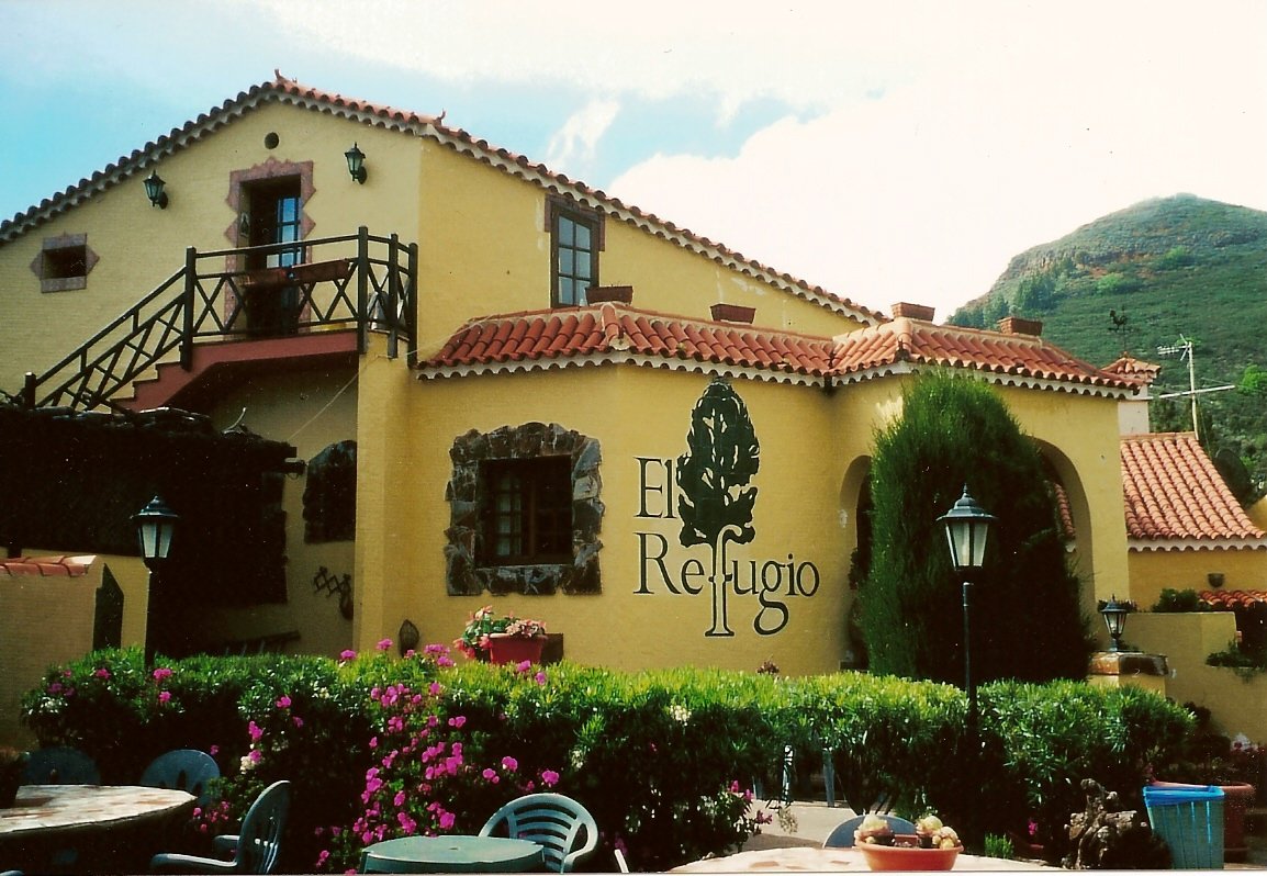 The road climbs with variations in elevation, with a flood of cars. Surprising, considering the time of day. The reason is the numerous villages along this small road. But that eases off later, and, to top off our misery, after the noxious gases, rain drops fall when they will. After crossing over the Dégollada de Pilétas (alt. 430 m/1411 ft) and the Alto de Las Arénas (alt. 1000 m/3281 ft), I descend without Barbara, who is a bit behind, to San Mateo (alt. 836 m/2743 ft) – three kilometers (almost two miles) of cool, damp downhill. Here, very little flat, which we appreciate. The road rises again, which will warm us. The climb is steep, the road well-paved and very winding. The landscape changes and offers differences in the flora of the three principal layers of the island, determined by the height and the orientation. It is, an exotic, enchanting landscape. Going through this radiant picture, we cross two passes light-heartedly, so to speak, because we are no longer very fresh – Alto Cabrera (alt. 933 m/3061 ft) and Las Lagunetas (alt. 1200 m/3937 ft). At the foot of the last climb of the day, we have only to raise our heads high to understand that it is no picnic. The mountain is steeper here. The woods of the middle zones extend to the end of our road through a thick fog, to Cruz de Téjéda (alt. 1500 m/4921 ft). Our eyes widen when, around a curve we see the sign for our shelter (El Refugio Hotel), which is well-named, considering how things are. As for the outdoor thermometer, it shows a good 9°C (49°F)! The wind and rain accompany our evening, making us shut ourselves in the hotel.
Tuesday, May 1: 3rd stage: Cruz de Téjéda - Cruz: 11 kms (7 miles): 2 passes
No Lily of the Valley here, but thick fog at daybreak and a cool temperature -- 5°C (41°F)! (Note: Traditionally, Lily of the Valley is sold in the streets of France on May 1, which is Labor Day.) The road surface being wet, we wait until the bad weather passes. The stage is short and not difficult – maybe we can start in the afternoon? We take a hard look at the vicinity of the pass where the view of the sunny “rocks” is extensive. Here we are imprisoned by the fog and icy wind, which motivates Barbara buy a balaclava! in one of the booths at the pass, which are well-stocked in winter clothes. The temperature has already risen from 5° to 8°C (41° to 46°F) — a little more effort and we could do a few strokes in the hotel's open-air swimming pool! With the weather improving only a bit, we decide to shorten our circuit from 41 km to 11 km (from 25 to 7 miles) with two passes (1580 m and 1720 m – 5183.7 feet and 5643 feet, the island’s highest passes) an out-and-back, quickly done and well done in the fog and wind, with car traffic and tourists in bikinis who, curiously this time, preferred to leave the beach and sun for the mountain’s bad weather (today’s maximum temperature 9°C/48°F).
Wednesday, May 2: Rest day
A repeat .... the same weather again. Thick fog and cold, 6°C (43°F), roads soaked, things to wonder about in spite of the encouraging weather forecast. The breakfast buffet is tempting. The clean air has given Barbara an appetite, and myself only slightly less. We spend the morning in the hotel and in the afternoon we take a bus trip below the pass (1500 m/4921 ft) to Téjéda (alt. 1049 m/3442 ft) at the bottom of a basin in a grandiose site. The descent from the pass is winding with many bends, and the climb is a memorable moment. At 1000 meters of altitude (3281 ft), the sky is clear, and the view of the stately mountains with their distinctive shapes is striking. The bit of sun warms the atmosphere. Returning to the hotel, the cold is still there and the thermometer indicates 8°C (46°F)!
Thursday, May 3: 4th stage: Cruz de Téjéda -- Cruz: 36 kms (22 miles): 4 passes
 We are still in the fog, the road surface is still wet and it is 6°C (43°F). We have to put up with it. The sun appears in the early
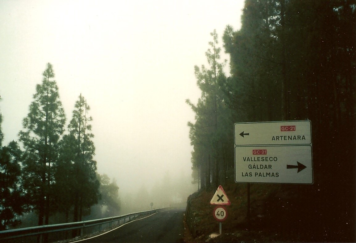
  afternoon and the road is almost dry. We start by climbing two passes (1623 m/5325ft and 1605 m/5266 ft) through thick fog and cold wind.Yet we are in the Canary Islands, but it is like January at home. The cold descent brings us to Artenera (alt. 1270 m/4167 ft). the island’s highest town, where the pine forest is omnipresent. Just below, the Alto de Los Cuernos (alt. 1197 m/3927 ft) then Dégollada de Tamadaba (alt. 1097 m/3599 ft) are crossed while descending to the entrance of a forestry nature reserve. With the return of the sun, the mountainous landscape with its distinctive rock forms appears in its true worth. To finish the stage at Cruz de Téjéda (1500 m/4921 ft), two choices are possible. One shorter and steeper (10 to 15 % grade), the other longer and easier (7 %). I convince Barbara to go for the more difficult one, and that road is closed to cars. A few drops of sweat, a fantastic landscape, a sprint by Barbara just before the top, and the circuit is finished.
Friday, May 4: 5th stage: Cruz de Téjéda -- Cruz: 66 kms (41 miles): 2 passes
 The top of the pass is still in the fog and the wind is still violent (6°C/43°F), but, after analysis, the fog invades only the summits. At 10:00, after an appetizing breakfast, we take off for the north of the island, 30 km/19 miles of descent and 36 km/22 miles of climbing for the return home. The cold penetrates us little by little because the sun is playing hide-and-seek. We descend to Teror where the sanctuary of the Virgin del Pino, the island’s patron saint, is located. The city, strategically wedged in a quite green valley between the mountains, connects the north and the center of the island. It is also necessary to emphasize the beautiful Canarian architecture of its streets, which calls to mind certain neighborhoods of American cities and villages. A short climb to Alto Cuevas de Gabelas (alt. 524 m/1719 ft) and a rather serious plunge to the foot of the cathedral at Arucas, located on a pass at 253 m/830 ft -- a beautiful city with an 18th century flavor in its traditional districts. We are at the lowest point. We have to climb to 1500 m/4921 ft, quite an elevation change over about 30 kilometers/19 miles, but the road winds through the island’s different types of woods – a good breath of oxygen. The arrival is near, in the immense forest, misty in places, but at the top a radiant sun rewards us for our efforts. In spite of the sun, the temperature at the pass stagnates at 10°C/50°F, and we spend the cool evening around the fireplace. The Canaries are like that, which we discover with astonishment -- the travel agencies hide their game well.
Saturday May 5: 6th stage: Cruz de Téjéda -- Los Berrazales : 120 kms (74.5 miles): 12 passes
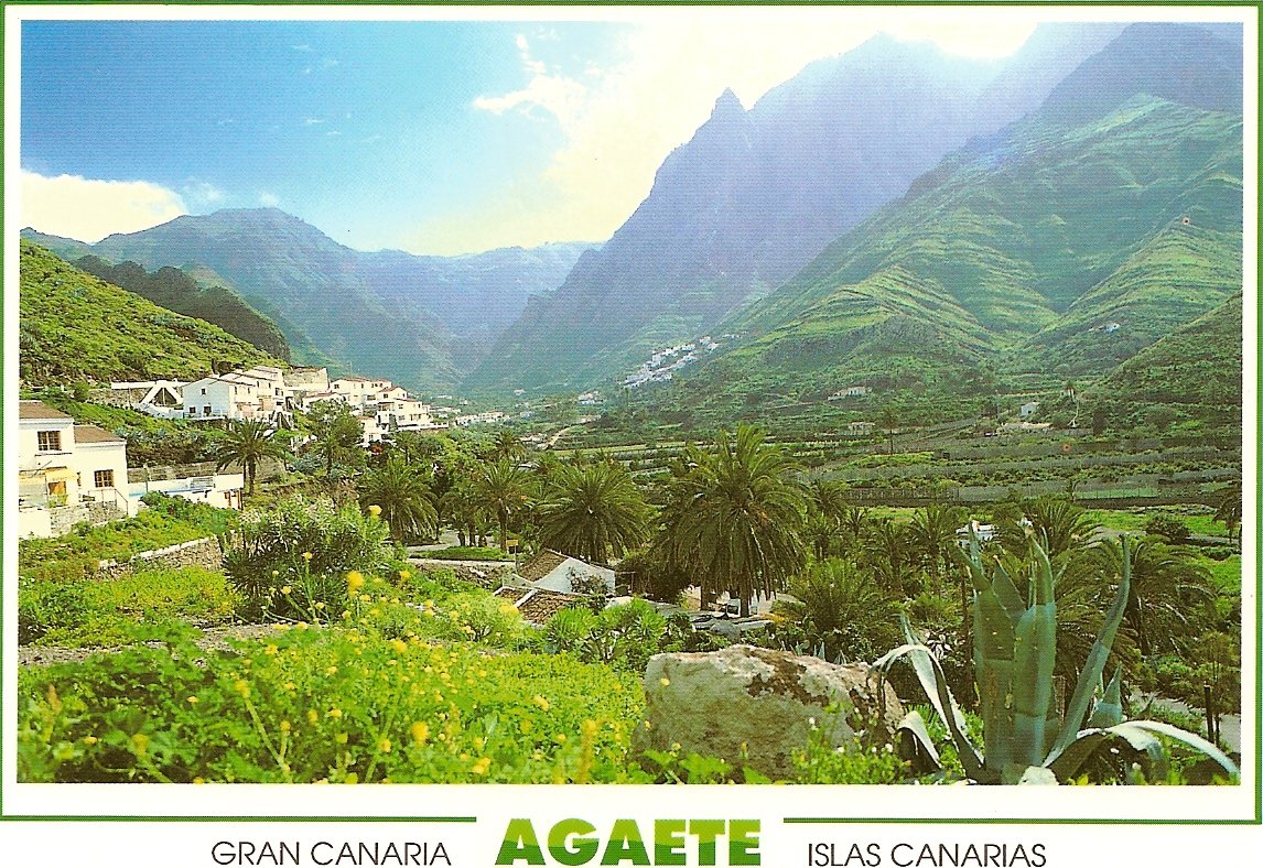
A long stage today to go to Agaete Valley. At 8:00 a.m. we raise the anchor and, still through the fog that systematically covers the summits around Cruz de Téjéda (1500 m/4921 ft), we descend, frozen, to Téjéda (alt. 1049 m/3442 ft). One can appreciate descents only under certain conditions. 10 kilometers (6.3 miles) of climbing might warm us up, for the sun begins to break through. A Dantesque landscape of peculiar rock formations – the moon or Mars? We have crossed four passes without a break (1197 m/3927 ft, 1276 m/4186 ft, 1325 m/4347 ft, 1410 m/4626 ft), nothing really funny. Then, the long descent to the fertile subtropical Mogan valley (alt. 350 m/1148 ft). Two passes along the way (950 m/3117 ft and 970 m/3182 ft), we can’t do without them, but we can do without the five kilometers (more than three miles) of unpaved road, which give Barbara some problems. At the bottom, we begin to smell pine trees. UNESCO considers Mogan’s micro-climate to be the best in the world (what chauvinism)!
 The heat is very much there. We head east for a little climb. This is not the Landes in spite of the fact that you can find passes here. La Cuesta (420 m/1378 ft) is almost nothing, followed by Vénéguéra (655 m/2149 ft) and Aldé (670 m/2198 ft). These two are serious customers, in a decor deprived of vegetation and very dry. A short hook to Tarsatico (579 m/1900 ft) in a strangely beautiful, grandiose site. Then we plunge down, too low for my taste, to Aldéa (64 m/210 ft) – hot, dry, and windy.
Well thought out, Charly, because we have to climb back up to Alto Carrizo (alt. 407 m/1335 ft) and to Las Cuevachones (alt. 500 m/1640 ft), where fatigue starts to set in. We overhang the sea on high, jagged cliffs. The road climbs and descents unceasingly, and the gusts of wind oblige Barbara to walk, which slows us down a lot. So, I take the lead in order to keep to the hotel’s check-in time (8 p.m.), but it is hard, among these steep, majestic rocks and breathtaking cliffs.
At Agaete (41 m/135 ft), it is already 8 p.m., and to reach the hotel, I have to follow the Agaete Valley beneath immense rocks, vertically hewn and crowned with pine forests. The valley is subtropical, favoring the cultivation of coffee or guavas. At 8:45 p.m., I reach my goal, exhausted, and hurry to have a taxi called to get Barbara. She is behind me, wondering if I will leave her to her sad fate and getting ready to spend the night outdoors, what a strange idea. Good news – the taxi found her near the hotel, and it is almost 10 p.m.
What a difficult day, but we need such a day for our memories, and without any more waiting, we eat like horses. Tomorrow, a rest day to recharge our batteries, in our water-therapy establishment with all the services that it offers: massages, Turkish baths, etc...
The heat is very much there. We head east for a little climb. This is not the Landes in spite of the fact that you can find passes here. La Cuesta (420 m/1378 ft) is almost nothing, followed by Vénéguéra (655 m/2149 ft) and Aldé (670 m/2198 ft). These two are serious customers, in a decor deprived of vegetation and very dry. A short hook to Tarsatico (579 m/1900 ft) in a strangely beautiful, grandiose site. Then we plunge down, too low for my taste, to Aldéa (64 m/210 ft) – hot, dry, and windy.
Well thought out, Charly, because we have to climb back up to Alto Carrizo (alt. 407 m/1335 ft) and to Las Cuevachones (alt. 500 m/1640 ft), where fatigue starts to set in. We overhang the sea on high, jagged cliffs. The road climbs and descents unceasingly, and the gusts of wind oblige Barbara to walk, which slows us down a lot. So, I take the lead in order to keep to the hotel’s check-in time (8 p.m.), but it is hard, among these steep, majestic rocks and breathtaking cliffs.
At Agaete (41 m/135 ft), it is already 8 p.m., and to reach the hotel, I have to follow the Agaete Valley beneath immense rocks, vertically hewn and crowned with pine forests. The valley is subtropical, favoring the cultivation of coffee or guavas. At 8:45 p.m., I reach my goal, exhausted, and hurry to have a taxi called to get Barbara. She is behind me, wondering if I will leave her to her sad fate and getting ready to spend the night outdoors, what a strange idea. Good news – the taxi found her near the hotel, and it is almost 10 p.m.
What a difficult day, but we need such a day for our memories, and without any more waiting, we eat like horses. Tomorrow, a rest day to recharge our batteries, in our water-therapy establishment with all the services that it offers: massages, Turkish baths, etc...
Sunday, May 6: Rest day
A day of sport, with one hour of full massage in the morning, and, in the afternoon, a walk to the end of the valley in a grandiose cirque.
Monday, May 7: 7th stage: Los Berrazales -- Los Berrazales : 32 km (20 miles): 2 passes
Cloudy sky with a light sprinkle this morning, but at the beginning of the afternoon, a few sunny spells appear. Barbara would rather rest, so I let myself slip downhill along Agaete Valley among palm trees and cactus until Agaete (alt. 41 m/135 ft). The sea being close, what is more normal than to expose myself to the wind in the climb up Las Cruces (alt. 200 m/656 ft). A few kilometers separate me from Galdar (alt. 143 m/469 ft), former residence of the “guanartemes”, or kings of the island. Alto Guia (alt. 186 m/610 ft) is very close, next to the autoroute interchange, so nothing very sensational. I quickly return to Agaete to avoid traffic, and start the long climb (7.5 km/4.6 miles) across the exotic valley to its end, where our hotel is standing like a strong, impregnable fortress.
Tuesday, May 8: 8th stage: Los Berrazales – Téjéda : 65 km (40 miles): 4 passes
It rained again last night, and this morning the sky is still cloudy with a light sprinkle here and there. We wonder, “When will we have a real sunny day?” Downhill departure across the sleeping valley to Agaete (alt. 41 m/135 ft). We hardly have time to become cold, for we start the first climb to Las Cruces (alt. 200 m/656 ft) in the wind. The direction toward the heart of the island is beneficial, for the wind pushes us. The air becomes cooler and colder, the dampness makes us keep wearing several layers of clothing. We climb slowly and easily, through the luxuriant vegetation. We are never bored and the mountainous setting is interesting to see. A few passes along the way to spice up the menu. Everything is good for the moment, but the Canary mountains always reserve their batch of surprises, but not for us anymore.
Above 1400 m/4593 ft, the mountains are always drowned in thick fog, and the end of the climb of Montana del Capitan (alt. 1594 m/5230 ft) is hard. But the worst is yet to come. The 7 km/4.3 mile decent to Artenera (alt. 1270 m/4167 ft) finishes off Barbara even more. At the bottom, she is in a state of exhaustion -- what to do to warm her up? Still 8 km/5 miles to finish the stage, but the wind plays its part. Her morale is low -- she hoped for sun in the Canaries. OK, a bit of courage, and we arrive at Téjéda (alt. 1049 m/3442 ft), nicknamed “the furnace” in summer.
Wednesday, May 9: 9th stage: Téjéda - Agüimes: 59 km (37 miles): 5 passes
I’m dreaming, you have to see it to believe it – blue sky for our return to the south of the island, and we have to wonder if there isn’t a weather barrier. From our hotel in Téjéda, we have a grandiose, panoramic view of the Roques and of the village with white houses set out in tiers on the mountain, The sun is really present, but the air remains cool. The departure is sloping for 10 kilometers with four passes that we have already crossed. The picture hasn’t changed but the light, yes, for it is almost 11 a.m. No traffic, except in the other direction because the tourists are coming back from the coast. Two other passes at 1200 meters/3937 feet are crossed without apparent effort, and now, the big descent to San Bartolomé and Santa Lucia (701 m/2300 ft). There, we leave the forest vegetation for another world, or rather, another planet, on a road overhanging immense canyons with strange contours, where nothing grows except some palm trees. You can’t really say that it is hot, because the cool wind is blowing all the time. The road climbs and descends, often winding, and we cross some additional passes. The sea is not far, but we have chosen to stay at the small town of Agüimes (alt. 286 m/938 ft), whose historic district is its only interest.
Thursday, May 10: 10th stage: Agüimes -Agüimes: 38 km (24 miles): 1 pass
After the copious breakfast, served as a buffet, we leave the historic district of Agüimes (alt. 286 m/938 ft) under a blue sky and radiant sun in all its splendor – so rare in the past 10 days! Warm temperature, but the wind is cool. The road follows the bottom of the Guayadčque ravine, and climbs abruptly. The site is sublime, a lot of vegetation on the ravine’s rocky slopes. At Guayadčque, a church and some bar-restaurants dug into the rock, to make the tourists stop, in small groups here. We continue the climb, which becomes more and more difficult for Barbara. The paved road ends at the top of a cliff, where there is a restaurant. The view is breathtaking.
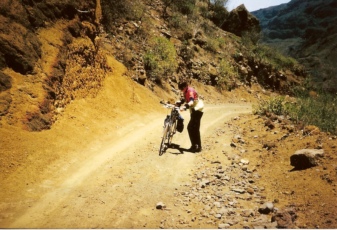
Now a trail, unpaved, broken up in places, with a steep grade, faces us. We have no choice – we have to take it to rejoin the paved road at the summit. For Barbara, it is the start of learning off-road cycling (Barbara’s note: not really!!), but on foot the whole way, pushing the bike with difficulty at a snail’s pace. The site is picturesque, but she wants only to finish with this difficulty as fast as possible. At the top, a last effort to reach Alto de Los Marteles (alt. 1500 m/4921 ft). This effort will not be the last for Barbara, because we have to descend 1200 meters/3937 ft lower over only 13 kilometers/eight miles, and this new trial is terrible for a person who suffers from vertigo. Her moral rises at the distant sight of the cupolas of the church at Agüimes, which dominate the old city. It is about time to arrive — I worried about arriving after nightfall.
Friday, May 11: Rest day
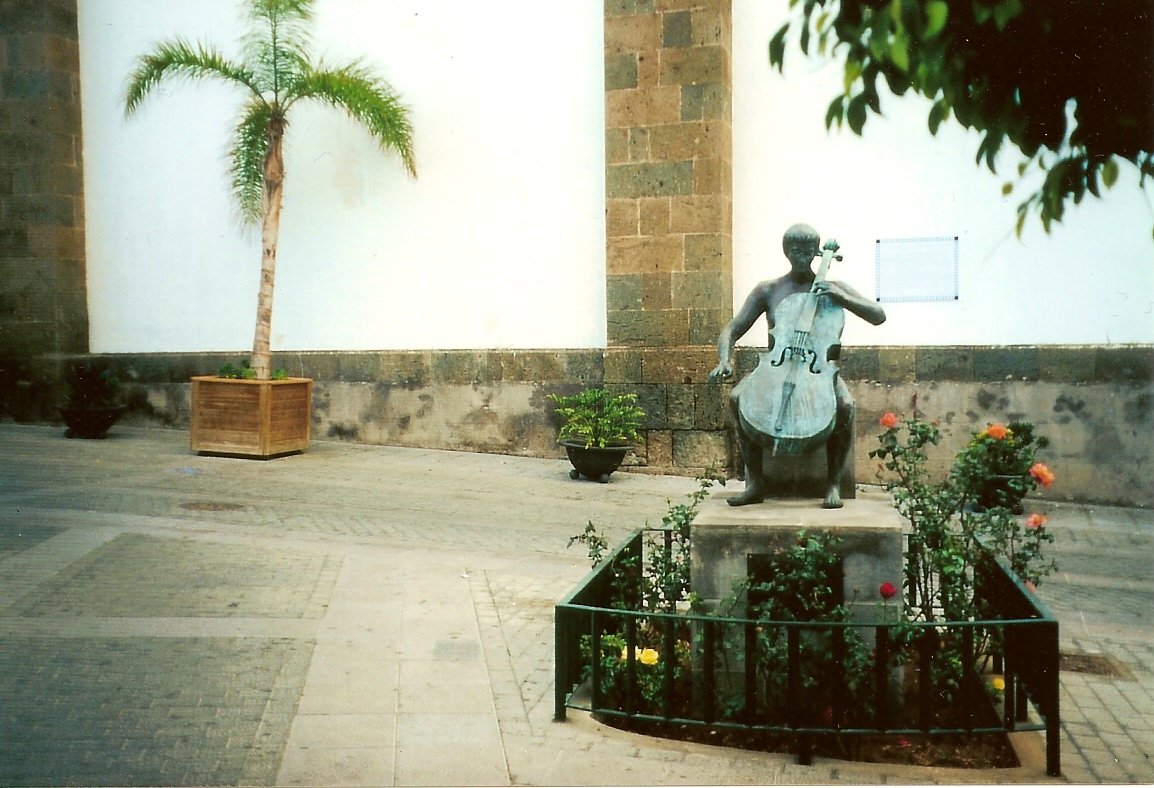
I think that now, the real Canary weather has settled in – sun, blue sky temperature 24°C/75°F. We rejoin our point of departure, at the Playa de Mélénara (yes, the wheel turns), 18 km/11 miles and one pass at 104 meters/341 feet, on the descent. In the afternoon, as tourists, we visit the nearby town of Telde, and particularly, the historical city with its labyrinth of small streets, which has a typical neighborhood called San Francisco “enough to give Barbara a certain nostalgia”.
Saturday, May 12: The trip: Las Palmas – Paris
The Iberia airplane takes off above the waves at 11:10 a.m. for the first stage to Barcelona, three hours later. Then for Paris with arrival at Roissy, which suits us, because the Air France bus deposits us at Porte Maillot, just a short walk to our respective homes.
Conclusion
This itinerant trip to Gran Canaria Island was so-so only in terms of the weather. The first week was windy, cool, foggy, with little sunshine, thus not agreeing with what we could expect of this small paradise. But the second week, with its sunny sky and bit of warmth showed the island’s true aspect. As for the countryside, we were not disappointed – startling contrasts, from exotic tropical valleys to forested mountains covered with luxuriant vegetation, and Dantesque volcanic contours. Well laid out mountain roads, so Gran Canaria Island is a small wonder of nature.
Charles Winter
Return to Bicycling à la Française